Saturday 24 October 2020

RIA DE AVEIRO (PORTUGAL)


RIA DE AVEIRO

40° 41′ 06″ N, 8° 39′ 21″ W

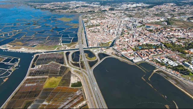
The Ria de Aveiro, also known as Foz do Vouga, is a lagoon that exists in the Aveiro region, between Ovar and Mira.

It is a shallow coastal lagoon with extensive intertidal zones, extending into the interior of Portuguese territory, parallel to the Atlantic Ocean, 45 kilometers long and with a maximum width of 11 kilometers. Its area covers two districts (Aveiro and Coimbra) and the towns of Aveiro, Estarreja, Ílhavo, Mira, Murtosa, Ovar and Vagos.

The ria is divided into three channels/zones: the Ovar Channel, the Ílhavo Channel and the Mira Channel.

Characteristics

The ria is the result of the retreat of the sea, with the formation of coastal ridges that, from the 16th century onwards, formed a lagoon that constitutes one of the most important and beautiful geographical features on the Portuguese coast.

In total, the entire mouth covers eleven thousand hectares, of which six thousand are permanently flooded, it unfolds into four important channels branched into streams that surround numerous islands and islets. The Vouga, Antuã, Boco and Fontão rivers flow into it, with the only communication with the sea being a channel that cuts the coastal line between Barra and São Jacinto, allowing access to the port of Aveiro for vessels with deep drafts.

Rich in fish and water birds, it has large areas of water, ideal places for practicing all water sports. Furthermore, even though it has been losing, from year to year, the importance it once had in Aveiro's economy, salt production, using ancient techniques, is still one of the most characteristic traditional activities of the city of Aveiro.

Tributaries

Antuã River

The Antuã River originates at an altitude of approximately 400 meters, in Monte Alto, in the town of Romariz, municipality of Santa Maria da Feira, and extends for approximately 38 kilometers until it flows into the Ria de Aveiro, in the Largo do Laranjo area, municipality of Estarreja. In some places, such as São João da Madeira and Vila de Cucujães, it is known as the Ul river, but in Ul the Antuã river is called the river that effectively bathes S. João da Madeira, Cucujães, S. Tiago de Riba Ul, Oliveira de Azeméis and Estarreja.

Rio Boco

The Boco River originates in the parish of Febres, in the town of Balsas, municipality of Cantanhede. It bathes the municipalities of Vagos and Ílhavo, flowing into the Ria de Aveiro. This watercourse may be called Ribeira or Rio Boco, being known, in times gone by, as Rio Salgado. It is known in the town of Bustos as Vala do Sardão.

Caster River

The Cáster river has its source in the parish of Sanfins, in the municipality of Santa Maria da Feira, crossing several parishes in that municipality and others in the neighboring municipality of Ovar, until it flows into the Ria de Aveiro, which has its northern limit in Carregal. Associated with this river, particularly through fishing and agriculture, have long been residents of Ribeira de Ovar who have depended on its quays — since the mid-18th century — to transport goods between Aveiro, Porto and other lands further inland. interior.

Tourism

The Aveiro ria is widely used for tourist purposes, particularly through its characteristic boats, the moliceiros. Moliceiro boat trips take place on the urban canals of the Ria de Aveiro:

Central Channel; Cojo Channel; Pyramids Channel; São Roque Channel; Canal dos Butirões.

These tours last an estimated 45 minutes and allow you to see the city's main attractions and monuments.


Grand Route of the Ria de Aveiro


Framework

This initiative's objective and investment priority is to promote the conservation, protection, promotion and development of the region's natural heritage, through its enhancement, particularly with regard to landscapes, leisure areas, fauna and local flora, complementing the local heritage cultural.

This project consists of creating the Grand Route of the Ria de Aveiro, with multimodal characteristics, namely pedestrian, cycling and nautical, based on the Fundamental Nature Conservation Network (RFCN), encompassing all Municipalities that make up CIRA. The project will make it possible to capitalize on the Ria de Aveiro as a destination par excellence for the practice of Nature Tourism through the structuring of the tourist offer in this segment.

This project was born within the scope of the Intermunicipal Community's candidacy for the “Proximity Investment” Dynamization Plan, Notice No. Centro-14-2016-05, and consists of the creation of the Grand Route of the Ria de Aveiro, with multimodal characteristics that allow experience of different areas, namely pedestrian, cycling and nautical. 

Goals

The project's fundamental objective is the conservation, protection, promotion and development of natural heritage, in such a way that the Ria de Aveiro brand can grow and assert itself as a Nature Tourism destination, through the promotion of ecologically friendly conduct. sustainable, which is a factor of differentiation and competitiveness. The valorization and qualification of the capital associated with natural resources and heritage will be a reality since the implementation of this project will allow the structuring of the tourist offer
in the Nature Tourism segment.

The creation of this Grand Route of the Ria de Aveiro naturally presupposes the implementation of the infrastructure necessary for its operation, including signage and support structures for visitors, the creation of an identity and the implementation of a marketing and communication plan based on the “Ria de Aveiro” brand. Aveiro”.

The definition of the route has as its premises, in addition to the inclusion of the Classified Areas that make up the RFCN, interconnection with existing routes in each municipality, as a result of investments in their own networks of Pedestrian Routes, MTB Centers and Cycle Paths. The objective is that a significant part of the routes can even serve local flows of people, based on soft or electric mobility providing healthier lifestyles and sustainable practices, consistent with the “Aveiro, Bicycle Region” strategy. The Grande Rota will also integrate the infrastructures of Polis Ria de Aveiro (managed in partnership with APA and ICNF) and Municipal Nature Conservation Projects (e.g. BioRia, NaturRia, CicloRia), as well as previous dissemination plans, such as the from EuroVelo.com, the European Cycling Challenge and the “Ria de Aveiro” brand itself, reinforced by contemporary projects, also inter-municipal in scope, such as the Cultural Program for the next 3 years and RAW – Ria de Aveiro Weekend. 

Expected results

The diversification of the region's tourist offer and its economic dynamism, proven by the triggering of new investments, the professionalization of the tourism sector and the creation of new jobs will result in an increase in the region's tourist attractiveness and the strengthening of territorial cohesion and strengthening of the feeling of identity. 

Managing entity

Intermunicipal Community of the Aveiro Region 

Participants

Municipality of Águeda
Municipality of Albergaria-a-Velha
Municipality of Anadia
Municipality of AveiroMunicipality of Oliveira do BairroMunicipality of VagosMunicipality of Sever do VougaMunicipality of OvarMunicipality of MurtosaMunicipality of Ílhavo
Municipality of Estarreja

Global budget

The overall budget of the project is €560,000.00, supported by the European Regional Development Fund through the national program Portugal 2020 / Centro 2020

Duration

The project lasted 56 months.

Connections


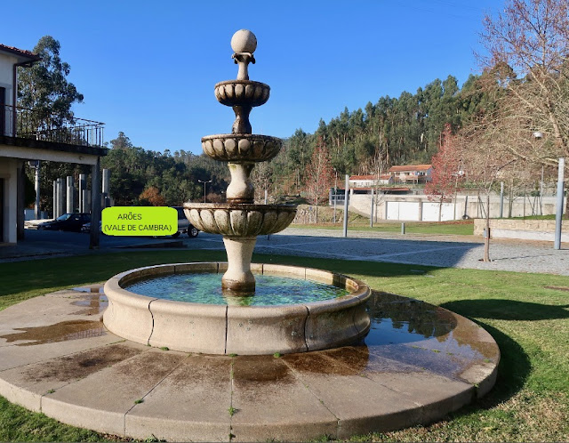
ARÕES + TREBILHADOURO (VALE DE CAMBRA)


ARÕES
40° 4' 49" N; 8° 17' 40" W

Arões is a Portuguese parish in the municipality of Vale de Cambra, with an area of 40.33 km² and 1169 inhabitants (2021 census). Its population density is 29 inhabitants/km².

Patrimony
Chapels of Saint Dominic, Saint Anthony
Parish residence
Castro de Aões
Dolmen of Campo de Arca
Cercal tapir
Lomba de Arãos
Serra da Freita
Sections of the Teixeira River and the Arões River
water mill core

The main populated places are:
Arões; Agualva; Cabrum; Campo D' Arca; Casal Velide; Carvalhal do Chão; Chão de Carvalho;
Cercal; Covo; Ervedoso; Cabeço Velide; Felgueira; Lomba; Mouta Velha; Paraduça;
Salgueira; Souto Mau; Moções e Quinta da Peninha.


https://freguesiaaroes.pt/portfolio/


💓💓💓💓💓

TREBILHADOURO

 N 40.867712º; W 8.341881º

Located in the district of Aveiro, municipality of Vale de Cambra. It maintains the original design of a farmers' land, it maintains the threshing floors and canastros, it is almost possible to hear the sound of the old leaves being removed. Practically uninhabited but fully recovered, with a range of highly qualified tourist homes, it is ready to welcome guests. A place of peace, it inspires long walks through the mountains.

  Uninhabited for decades, it maintains the traditional Portuguese rural house made of granite stone, a material that extends onto the paths.

The threshing floors and canastros that abound throughout the village remind us of other times when leafless people lived intensely, to the sound of singing, concertinas and violas.

The community spirit is also evident in equipment such as the public tank and fountain. Lost on the slopes of the Serra da Freita, it is possible to see the sea and the Aveiro ria from here.

Greenery abounds on these slopes, which is worth exploring. Pines and eucalyptus trees dominate the surrounding vegetation and the slope is also marked by terraces, dividing small agricultural plots. Explore this beautiful place without rushing, take a deep breath of the mountain air and get ready for a good walk!

Points of interest

Main Church of São Salvador, Cruzeiro de Roge, Chapel of Saint Helena, Fonte de Roge,

Mau Vizinho Castle Bridge, Cave Paintings.


AROUCA UNESCO GLOBAL GEOPARK (PORTUGAL)


AROUCA UNESCO GLOBAL GEOPARK

N 40°55'56'', W 008°14'42''

The Arouca Geopark corresponds to the administrative area of the municipality of Arouca, district of Aveiro, in Portugal. It includes Serra da Freita and Passadiços do Paiva.

Originated in 2005 and formally created in 2007, it has been part of the World Geoparks Network since April 22, 2009.

41 places of geological interest were inventoried, demonstrating the high geodiversity of the area.

Geosites
Of the set of 41 identified geosites, four of international importance stand out, namely Frecha da Mizarela (largest waterfall in Portugal), the fossil collection at the Canelas Geological Interpretation Center (with the largest trilobites in the world) and the Castanheira Fold Field.

What if suddenly you were presented with a live book telling the history of the Earth represented on the rocky landscape, the rivers running in a hurry, the green of the landscape, and the silence of the mountain? Yes, in the Arouca Geopark it is possible to travel in space and time. Those who arrive here are surprised at each step, and the destination is not only the end of the journey. It is, on the contrary, the beginning of another adventure, going back in time, until the beginning of a history with more than 500 million years.

Please note: the entire municipality of Arouca is classified as geopark. Every centimeter of the 328 square kilometers. Every smile that welcomes the ones who arrive here. Every heather flower painting the Freita Mountain’s plateau. Every drop of water from the Paiva River’s rapids. This huge green cloak has 41 geological interesting sites (geosites), and almost half of them are classified by the Natura 2000 network.

But, more than arrive here, we must live. And to live means passing through unique experiences that arise in this place. There are pedestrian trails to go through, to meet and to record on the best photo albums of the memory. There are amazing trails that let the adventure continue by mountain biking. There are explosions of adrenaline in the adventure sports of the Paiva. There are traditional villages that keep and plan for the future the memory of those who lived and still live here. There is the craftsmanship, the folklore and the traditions that keep telling our history. And all that makes part of us and defines us is kept and preserved here, waiting for the moment to be told and left has a heritage to the future generations.

So, here, you will always have your place in history. In the history of the Earth. In our history. In your history. In a new history that we’ll write together from the moment we tell you «Welcome to the Arouca Geopark».


How to get

The Arouca Geopark is a territory to arrive and to stay. The discovery starts with the journey. This unique and unforgettable destiny is not too far from the roads like A1 and A32 (at the west), the A4 (at north), the A24 and A25 (at south) and at one hour by car from the cities of Aveiro and Porto, at about one and a half hours from the cities of Coimbra, Viseu and Braga, and at two hours from Lisbon. You will want to come back to discover new surprises.

After you leave the main roads (highways), the EN225 and EN326 national roads are the best alternatives to arrive at the Arouca Geopark. 

North/South direction

(A1)
Exit: Santa Maria da Feira/São João da Madeira/Vale de Cambra/Arouca

After you leave the A1, the estimated travel time to the Arouca Geopark is 40 minutes. 

(A32)
Exit: Carregosa/Pindelo/Vale de Cambra/Arouca
After you leave the A32, the estimated travel time to the Arouca Geopark is 40 minutes. 

South/North direction

(A1)
Exit: Estarreja/Oliveira de Azeméis/Vale de Cambra/Arouca
After you leave the A1, the estimated travel time to the Arouca Geopark is 45 minutes. 

East/West direction

(A25)
Exit: Porto (A1) – Estarreja/Oliveira de Azeméis/Vale de Cambra/Arouca
After you leave the A25, the estimated travel time to the Arouca Geopark is 45 minutes. 

(EN225)
Cinfães/Castro Daire/Castelo de Paiva
Depending on the point of departure, the estimated travel time to the Arouca Geopark can vary between 30 and 60 minutes.